Posts

Showing posts from January, 2021

Croydon in a winter wonderland

Image
Today it snowed! Sadly it then sleeted, so the snow didn't stick around long. It brought back memories of other times it's snowed here.  2008 The oldest snow photos I have in Croydon are from April 2008. I remember that I'd been in Bristol the previous day sitting in the sun and then when I got back to Croydon, it snowed. The photo below is from Park Hill Park, in the walled garden which is now run by the Friends of Park Hill. You can see Taberner House, since demolished, left of centre behind the trees. 2010 In November 2010, it snowed more heavily and I went out with a friend to take photos. The photo below shows traffic in the town centre heading towards the Flyover, with Taberner House on the right.  East Croydon bus station Snow falling on North End Police station looking unusually picturesque Taberner House from Fairfield Halls forecourt Snowy Almshouses Looking down Barclay Road towards Taberner House Barclay Road crossing by Fairfield Halls Looking up George St towa

Highs and lows of Croydon

Image
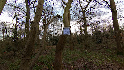
Today I found Croydon's highest point, in Sanderstead Plantation. It could be better signposted, but I appreciate the effort that somebody has gone to in marking it.  It's inspired me to look at a topographic map and find out how high the other high and low points of Croydon are. The topographic map reckons the top of Sanderstead Plantation is 181 metres above sea level, while the sign there says it's 175 metres, but it's not a big difference. IKEA car park, 37m above sea level. Sep 2011. Generally speaking, the lowest points of Croydon are to the west and north west, around Purley Way, Waddon, Mitcham Road and Norbury. There are some low lying areas in South Norwood Country Park too. I was surprised to learn that Beulah Hill, where the TV transmitter is, is around 50 metres lower than Sanderstead Plantation. On the photo above, taken from Sanderstead Plantation, the Beulah Hill transmitter is on the left, while the Crystal Palace transmitter is on the right. To right o

Wet wet wet

Image
I've been slipping, sliding and squelching my way through Croydon's green spaces recently. Every time I come home, I bring souvenirs with me, in the form of mud. My trouser legs look like Jackson Pollock has had a go at them with some brown paint.  This time of year, there's water everywhere and many of our parks are flooded. I've seen people concerned about this, particularly as parks are especially important at the moment. However, their tendency to flood is a key reason why some of these sites remain public land.  Ashburton Park, Jan 2021 Croydon's green spaces used to have more ponds and lakes than they currently do.  The current "flooding" in Ashburton Park pretty much exactly matches the location of the lake on this map from 1898 ( available on the National Library of Scotland website here ).  Wandle Park was the site of Croydon's first sewage treatment works, however this was short-lived, being replaced by an abbatoir. Despite this insalubrious